|
Week of May 7, 2001 Editor's Choice Web Pick |
|
GlobeXplorer.com: Lightning-Fast  Satellite Images Could Rattle Old-Line Mapping Order Satellite Images Could Rattle Old-Line Mapping Order
By JACK LYNE • Site Selection Executive Editor of Interactive Publishing
Visual Information:  "Aerial images convey 80 percent more information than drawn maps or simple diagrams," GlobeXplorer.com asserts. "Aerial images convey 80 percent more information than drawn maps or simple diagrams," GlobeXplorer.com asserts.
Obviously, that's the type of self-promotion we'd expect. Just as obviously, definitively quantifying such a quantum leap in visual information would seem to fall into the very, very deep end of the statistical speculation pool. Nonetheless, a look at GlobeXplorer.com lends some weight to the site's argument. (Although we'll leave it to individual users to determine their own designated percentage gain in visual information.) 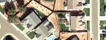
You get part of the picture of the online goods from the "Image Library" section of the redesigned site, which debuted on March 1. You can click on sample maps at the "world/country," "regional," "city," "neighborhood," "street" and "property" levels. The level of detail in the city, neighborhood and street shots is particularly impressive (see examples accompanying this feature). Users, for example, can readily pick out trees, shadows and cars. There simply is a lot more to see here than with traditional maps. It's all in the details: Online images of downtown San Francisco (above right) and of one property in Bay-area city (above left) demonstrate some of the visuals in GlobeXplorer's 12 terabyte archive of satellite images.
Cruising the World's Cities from the Skies You'll find other rich visuals in GlobeXplorer.com's "Image Viewer" section. There, you can select from a host of options that include world cities and U.S. airports, golf courses, and national parks.The Image Viewer photos are also simply fun. Users can zoom in and out, as well as to pan left and right and up and down. You can pleasantly blow some time here by trying to zero in on some favorite part of a city with which you're familiar. (Helpfully, user options include "re-center." You may need that, as it's quite easy to become disoriented with all the zooms and pans.) For all GlobeXplorer.com's visual goodies, however, our test drive didn't turn up definitive pricing information. That's because GlobeXplorer.com employs a transaction-based subscription model; users pay an annual fee based on usage. Usage options include adding layers of useful customize information, like demographics, to selected maps. That obviously adds image value - and cost. It's not hard to see potential industry benefits in GlobeXplorer.com's images. But are those benefits enough to elevate satellite imagery to the rank of a location-strategy essential? The real estate industry's jury is out on that one; and it won't have to come back with a unanimous verdict. Unquestionably, though, GlobeXplorer's 12-terabyte archive has massive gobs of power behind it. The system is equipped with a total of 36 CPUs, and it's designed to handle up to 3 million hits a day. (Sun Microsystems and MapQuest are the principal technology partners with Walnut Creek, Calif.-based GlobeXplorer.) Those tons of technological juice are what make GlobeXplorer's online images a seconds-away reality. And they also make such from-the-clouds mapping a viable, very down-to-earth strategic option. |
 PLEASE VISIT OUR SPONSOR • CLICK ABOVE
©2001 Conway Data, Inc. All rights reserved. Data is from many sources and is not warranted to be accurate or current.